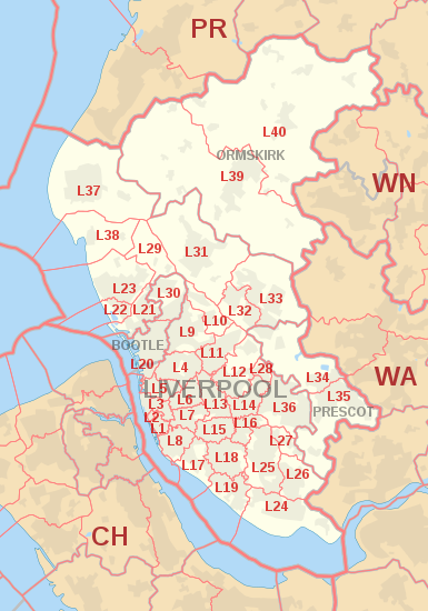
Obszar kodu pocztowego L - L postcode area
Granice okręgów pocztowych :
Liverpool | |
|---|---|
| Współrzędne: 53,443 ° N 2,926 ° W 53 ° 26′35 ″ N 2 ° 55′34 ″ W. / | |
| Kraj | Zjednoczone Królestwo |
| Obszar kodu pocztowego | L |
| Nazwa obszaru kodu pocztowego | Liverpool |
| Miasta pocztowe | 4 |
| Dzielnice kod pocztowy | 65 |
| Sektory kodu pocztowego | 581 |
| Kody pocztowe (na żywo) | 20,440 |
| Kody pocztowe (łącznie) | 43,224 |
| Statystyki na maj 2020 r | |
Obszar kodu pocztowego L , znany również jako obszar kodu pocztowego Liverpool , to grupa okręgów pocztowych w północno-zachodniej Anglii, które są podziałem czterech miast pocztowych. Obejmują one większość Merseyside (w tym Liverpool , Bootle i Prescot ), część zachodniego Lancashire (w tym Ormskirk ) i niewielką część północno-zachodniego Cheshire .
W 1999 roku kody pocztowe dla półwyspu Wirral (L41-49, 60-66) zostały przeniesione do obszaru CH .
Pokrycie
Przybliżony zasięg okręgów pocztowych:
| Dzielnica kod pocztowy | Poczta | Pokrycie | Obszar (y) władz lokalnych |
|---|---|---|---|
| L1 | LIVERPOOL | Centrum miasta | Liverpool |
| L2 | LIVERPOOL | Centrum miasta | Liverpool |
| L3 | LIVERPOOL | Centrum miasta , Everton , Vauxhall | Liverpool |
| L4 | LIVERPOOL | Anfield , Kirkdale , Walton | Liverpool |
| L5 | LIVERPOOL | Anfield , Everton , Kirkdale , Vauxhall | Liverpool |
| L6 | LIVERPOOL | Anfield , centrum miasta , Everton , Fairfield , Kensington , Tuebrook | Liverpool |
| L7 | LIVERPOOL | Centrum miasta , Edge Hill , Fairfield , Kensington | Liverpool |
| L8 | LIVERPOOL | Centrum miasta , Dingle , Toxteth | Liverpool |
| L9 | LIVERPOOL | Aintree , Fazakerley , Orrell Park , Walton | Liverpool, Sefton |
| L10 | LIVERPOOL | Aintree Village , Fazakerley , Kirkby | Sefton, Liverpool, Knowsley |
| L11 | LIVERPOOL | Clubmoor , Croxteth , Gillmoss , Norris Green | Liverpool |
| L12 | LIVERPOOL | Croxteth Park , West Derby | Liverpool |
| L13 | LIVERPOOL | Clubmoor , Old Swan , Stoneycroft , Tuebrook | Liverpool |
| L14 | LIVERPOOL | Broadgreen , Dovecot , Knotty Ash , Page Moss | Liverpool, Knowsley |
| L15 | LIVERPOOL | Wavertree | Liverpool |
| L16 | LIVERPOOL | Broadgreen , Bowring Park , Childwall | Liverpool, Knowsley |
| L17 | LIVERPOOL | Aigburth , St Michael's Hamlet , Sefton Park | Liverpool |
| L18 | LIVERPOOL | Allerton , Mossley Hill | Liverpool |
| L19 | LIVERPOOL | Garston , Grassendale , Aigburth , | Liverpool |
| L20 | BUTELKA | Bootle , Orrell | Sefton |
| LIVERPOOL | Kirkdale | Liverpool | |
| L21 | LIVERPOOL | Ford , Litherland , Seaforth | Sefton |
| L22 | LIVERPOOL | Waterloo | Sefton |
| L23 | LIVERPOOL | Blundellsands , Brighton-le-Sands , Crosby , Little Crosby , Thornton | Sefton |
| L24 | LIVERPOOL | Hale , Speke | Halton , Liverpool |
| L25 | LIVERPOOL | Belle Vale , Gateacre , Hunts Cross , Woolton , Halewood | Liverpool, Knowsley |
| L26 | LIVERPOOL | Halewood | Liverpool, Knowsley |
| L27 | LIVERPOOL | Netherley | Liverpool |
| L28 | LIVERPOOL | Stockbridge Village | Liverpool, Knowsley |
| L29 | LIVERPOOL | Lunt , Sefton Village | Sefton |
| L30 | BUTELKA | Bootle , Netherton | Sefton |
| L31 | LIVERPOOL | Maghull , Lydiate , Melling , Waddicar | Sefton |
| L32 | LIVERPOOL | Kirkby | Knowsley |
| L33 | LIVERPOOL | Kirkby | Knowsley |
| L34 | PRESCOT | Prescot , Knowsley Village | Knowsley |
| L35 | PRESCOT | Prescot , Whiston , Rainhill | Knowsley, St Helens |
| L36 | LIVERPOOL | Huyton , Roby , Tarbock | Knowsley |
| L37 | LIVERPOOL | Formby , Mały Altcar , Wielki Altcar | Sefton, West Lancashire |
| L38 | LIVERPOOL | Ince Blundell , Hightown | Sefton, West Lancashire |
| L39 | ORMSKIRK | Ormskirk , Aughton | West Lancashire |
| L40 | ORMSKIRK | Burscough , Mawdesley , Scarisbrick , Rufford , Holmeswood | West Lancashire, Chorley |
| L67 | LIVERPOOL | Baseny Littlewoods | niegeograficzne |
| L68 | LIVERPOOL | Baseny Vernons | niegeograficzne |
| L69 | LIVERPOOL | Skrzynki pocztowe w centrum Liverpoolu, departamenty rządowe w Liverpoolu i Bootle, University of Liverpool | niegeograficzne |
| L70 | LIVERPOOL | sezonowa poczta zwrotna | niegeograficzne |
| L71 | LIVERPOOL | American Express | niegeograficzne |
| L72 | LIVERPOOL | Littlewoods | niegeograficzne |
| L73 | LIVERPOOL | Grupa BT , duzi użytkownicy Selectapost | niegeograficzne |
| L74 | LIVERPOOL | HM Revenue and Customs (Cła i Akcyza) | niegeograficzne |
| L75 | LIVERPOOL | HM Revenue and Customs (Inland Revenue) | niegeograficzne |
| L80 | BUTELKA | niegeograficzne |
Mapa
|
Plik KML ( edycja • pomoc )
|


