Autotrasa A75 — A75 autoroute
A75 jest Autoroute ( autostrada ) w Francji .
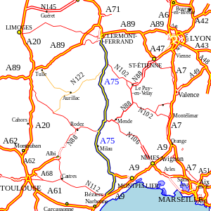
Znany również jako la Méridienne , jest to projekt rozwojowy mający na celu przyspieszenie i zmniejszenie kosztów podróży samochodem z Paryża na południe, a oprócz wiaduktu Millau , jest całkowicie bezpłatny na 340 km (210 mil) między Clermont- Ferrand i Béziers . Miała zostać ukończona wiosną 2011 roku, ale została w pełni otwarta w grudniu 2010 roku.
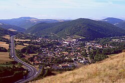
Na południe od St . Flour są wspaniałe widoki na wiadukt Garabit .
Duża część A75 jest również częścią europejskiej trasy E11 .
Osiągnięcia inżynierskie

Budowa autostrady przez Masyw Centralny jest sama w sobie ogromnym osiągnięciem. Duża część autostrady biegnie na wysokości ponad 800 m (2600 ft), przy czym 50 km przekracza 1000 m (3250 ft).
Najbardziej imponującym elementem jest niewątpliwie wiadukt Millau , który prowadzi drogę przez Tarn . Został zbudowany na podstawie kontraktu rządowego z grupą Eiffage , obowiązującego 75 lat. Eiffage pobiera opłaty za przejazd według uzgodnionych stawek, co sprawia, że jest to jedyna płatna część A75.
Inne imponujące funkcje to:
Wiadukty i mosty
- Viaduc de la Violette o długości 560 m, między skrzyżowaniami 21 i 22
- Pont sur la Truyère, długość 311 m, między skrzyżowaniami 30 i 31
- Viaduc du Piou o długości 414 m, między skrzyżowaniami 38 i 39
- Viaduc du Ricoulong o długości 342 m, między skrzyżowaniami 38 i 39
- Viaduc de la Planchette o długości 221 m, między skrzyżowaniami 38 i 39
- Viaduc de Verrières o długości 710 m, między skrzyżowaniami 44 i 44,1
- Viaduc de la Garrigue o długości 340 m, między skrzyżowaniami 44.1 i 42
- Viaduc de Millau o długości 2500 m, między skrzyżowaniami 45 i 46
Karnety
- 990 m między skrzyżowaniami 24 i 25
- Col de la Fageole, 1107 m, między skrzyżowaniami 26 i 27
- Col des Issartets, 1121 m, najwyższy punkt na A75, między skrzyżowaniami 36 i 37
- Col de la Fagette, 882 m, między skrzyżowaniami 40 i 41
- Col d'Engayresque, 888 m, między skrzyżowaniami 44 i 44,1
Tunele
- Tunel de Montjezieu o długości 616 m na wysokości 650 m, pomiędzy węzłami 39,1 i 40
- Tunel de Pas d'Escalette, 725 m w kierunku południowym, 830 m w kierunku północnym, między węzłami 50 i 51
- Tunel de la Vierge, 474 m, między skrzyżowaniami 52 i 53
Trasa
|
A75 Skrzyżowania z Autostradą, wymienione z północy na południe |
||||
| km | Jun. Nie. | Wyjścia w kierunku północnym | Zjazdy w kierunku południowym | Uwagi |
| 0 |
|
A71 staje się A75 w Clermont-Ferrand | ||
| 1,5 |
|
La Pardieu, Billom , Cournon | Billom | Brak wjazdu w kierunku północnym |
| 4 |
|
Bordeaux , La Bourboule , Le Mont Dore , Aubière | La Bourboule , Le Mont Dore , Aubière | |
| 5 |
|
Pérignat- lès- Sarliève , ZI Cournon , La Roche Blanche , Orcet , Le Cendre | Courn | |
| 6,5 |
|
Orcet , Le Cendre , Vic-le-Comte , La Roche-Blanche | Le Cendre , Pérignat- lès- Sarliève , La Roche- Blanche | |
| 10 |
|
Veyre-Monton , St-Amant-Tallende | Orcet , St-Amant-Tallende , Aydat | |
| 15 |
|
Veyre- Monton , Murol , Chambon sur Lac , Champeix , St Nectaire | Veyre-Monton | |
| 18,5 |
|
Montpeyroux , Coudes | Montpeyroux | |
| 21 |
|
- | Coudes , Vic-le-Comte | Tylko wjazd w kierunku południowym i wyjazd w kierunku północnym |
| 23 |
|
Sauvagnat , St-Yvoine | Sauvagnat , St-Yvoine | |
| 26,5 |
|
La Ribeyre | La Ribeyre | |
| 28,5 |
|
Centrum Issoire | - | Tylko wyjście w kierunku południowym i wejście w kierunku północnym |
| 31 |
|
Issoire -les-Prés, Orbeil | Issoire -les-Prés, Orbeil | |
| 31,5 |
|
Issoire couze, Parentignat , Sauxillanges , Ambert , St Germain | Issoire couze, Parentignat , Sauxillanges , Ambert | |
| 34 |
|
Lotnisko Issoire | Centrum Issoire , Champieux, St Nectaire , Besse | Brak wjazdu w kierunku północnym |
| 39 |
|
Le Broc , St Germain, Ardres , Le Breuil | - | Brak wyjścia w kierunku północnym |
| 38 |
|
- | Le Broc | Brak wyjścia na południe |
| 41 |
|
St-Germain-Lembro , Jumeaux | St-Germain-Lembron , Le Breuil | |
| 45,5 |
|
Charbonnier , Brassac , Ste Florine | Brassac , Charbonnier | |
| 50 |
|
Lemdes | - | Tylko wyjście w kierunku południowym i wejście w kierunku północnym |
| 51 |
|
Lempdes , Vergongheon , Brioude , Le Puy en Velay | Lempdes , Vergongheon , Ste Florine , Le Puy en Velay | |
| 56 |
|
Lorlanges | Lorlanges , Ardres s. Kuze | Aire de Lafayette przez to skrzyżowanie |
| 61 |
|
Espalem , Blesle , Brioude | Le Puy en Velay , Espalem , Blesle , Brioude | |
| 66 |
|
Massiac , Aurillac , Murat, Le Lioran | - | Tylko wyjście w kierunku południowym i wejście w kierunku północnym |
| 68,5 |
|
- | Massiac | Tylko wjazd w kierunku południowym i wyjazd w kierunku północnym |
| 81 |
|
St-Poncy | St-Poncy | |
| 85 |
|
Vieillespesse | Vieillespesse | |
| 87,5 |
|
Coren, Montchamp | Montchamp | |
| 92,5 |
|
St-Flour , Chaudes-Aigues , Espalion | St-Flour bel-air, Coren | |
| 96,5 |
|
St-Flour belle vue, St Georges | Aurillac , centrum St Flour , Murat, Le Lioran | |
| 100,5 |
|
Ruynes-en-Margeride | Ruynes-en-Margeride | |
| 108,5 |
|
Loubarese | Loubaresse , Viaduc de Gabarit | |
| 117 |
|
La Garde, Le Bacon | La Garde, Le Bacon | Dostęp do usług La Lozère i Geoscope |
| 122,5 |
|
St-Chély-d'Apcher , Le Malzieu-Ville , Fournels | - | Tylko wyjście w kierunku południowym i wejście w kierunku północnym |
| 128,5 |
|
St-Chély-d'Apcher , Rimeize , St-Alban-sur-Limagnole | St-Chély-d'Apcher , St-Alban-sur-Limagnole , Le Malzieu- Ville , Fournels | |
| 134 |
|
Aumont-Aubrac , Nabrinals | - | Tylko wyjście w kierunku południowym i wejście w kierunku północnym |
| 138,5 |
|
- | Aumont-Aubrac | Tylko wjazd w kierunku południowym i wyjazd w kierunku północnym |
| 146,5 |
|
Le Buisson | Le Buisson | |
| 153 |
|
Antrenes, Marvejols | Antreny, Marvejole , Nasbinale | |
| 162 |
|
Le Monastier , Chirac , Chanac , Florac | Mende , Le Monastier , Chirac , Chanac , Florac | |
| 163 |
|
|||
| 168,5 |
|
St-Germain-du-Teil | - | Tylko zjazd w kierunku południowym |
| 172 |
|
La Canourge, Banassac , St-Germain-du-Teil | La Canourge, Banassac , St-Germain-du-Teil | |
| 182,5 |
|
Campagnac , St-Geniez-d'Olt | Campagnac , St-Geniez-d'Olt | |
| 190 |
|
Rodez , Sévérac- le- Château , le Massegros , Laissac | Rodez , Sévérac-le-Château , Laissac | Skrzyżowanie A68. Dostęp do usług Aveyron |
| 193 |
|
- | Le Massegros | Tylko wjazd w kierunku południowym i wyjazd w kierunku północnym |
| 200,5 |
|
Engayresque | Engayresque | |
| 210 |
|
Aguessac , Micropolis , Vezins de Levezon , Pont de Salars , Meyrenes | Cahors , Aguessac , Pont de Salars , Meyrenes | |
| 215 |
|
St-Germain, St Beauzély , Castelnau de Petgarolles | Millau , St Beauzély , Castelnau de Petgarolles | ODCINEK OPŁAT NA POŁUDNIE DO WĘZŁA 46 |
|
|
Bariera płatna | |||
| 223 |
|
La Bastide-Pradines , St-Rome-de-Cernon , Roquefort , St Affrique | - | ODCINEK OPŁAT NA PÓŁNOC DO WĘZŁA 45 |
| 234,5 |
|
Millau sud, la Cavalerie , Sainte-Eulalie-de-Cernon | Millau , la Cavalerie , Roquefort , St Affrique | |
| 244 |
|
L'Hospitalet-du-Larzac , La Couvertoirade , Cornus , Alzon , La Vigan | L'Hospitalet-du-Larzac , Cornus , Alzon | |
| 257,5 |
|
Le Caylar , Lunas , Bedarieux , Cirque de Navacelles | Le Caylar , La Couvertoirade | Dostęp do usług Le Caylar |
| 260 |
|
- | St-Félix-de-l'Héras | Tylko wjazd w kierunku południowym i wyjazd w kierunku północnym |
| 267 |
|
Pégairolles-de-l'Escalette | Pégairolles-de-l'Escalette | |
| 271,5 |
|
Lodève nord, Soubès | Le Vignan, Ganges , Lodève nord, Soubès | |
| 275,5 |
|
- | Lodève Sud, Lunas | Tylko wjazd w kierunku południowym i wyjazd w kierunku północnym |
| 280 |
|
Le Bosc | Le Bosc | Brak wjazdu na południe |
| 283 |
|
- | Le Bosc , Lac du Salagou | Tylko wjazd w kierunku południowym i wyjazd w kierunku północnym |
| 285-289,5 |
|
Salelles | Salelles, L'Oasis | Brak wjazdu na południe |
| 289,5 |
|
Montpellier | Montpellier , Saint-Guilhem-le-Désert , Gignac , St André-de-Sangonis | Połączenie z A750 |
| 294,5 |
|
Clermont-l'Hérault , Nébian , Canet, Bedarieux | Clermont-l'Hérault , Bedarieux , Canet , Lac du Salagou | |
| 305,5 |
|
Paulhan , Adissan , Lézignan-la-Cèbe | Paulhan , Adissan | |
| 310 |
|
Pézenas nord, Sete , Montagnac , Mèze , Marseillan | Sete , Montagnac , Mèze , Marseillan | |
|
|
Pézenas sud, Castelnau-de-Guers | Pézenas sud, Castelnau-de-Guers | ||
|
|
Agde , Cap d'Agde | - | Tylko wyjście w kierunku południowym i wejście w kierunku północnym | |
|
|
Pezenas ouest | Roujan , Pézenas ouest | ||
| 324 |
|
Serbski , Montblanc | Florensac , Servian , Valros , Montblanc | |
| 331 |
|
Narbonne , Centrum Béziers | - | Tylko wyjście w kierunku południowym i wejście w kierunku północnym |
| 332 |
|
Valras-Plage , Serignan , Béziers Port lotniczy Cap d'Agde , Béziers | Centrum Béziers | |
| 333 |
|
Bariera płatna | ||
| 334 |
|
Połączenie z A9 | ||
- † Odcinek między węzłami 59 i 61 (obwodnica Pézenas) nie był technicznie autostradą i nadal był oznaczony jako N9, pomimo tego, co widać na większości map. Prace nad doprowadzeniem odcinka do pełnej autostrady trwały od września 2013 r. do czerwca 2014 r.
W maju 2007 r. rozpoczęto budowę ostatniego odcinka A75, łączącego Pézenas z autostradą A9 mniej więcej kilometr na wschód od poprzedniego skrzyżowania Béziers East 35. Trasa na południe od obecnej drogi D609 Pézenas-Béziers omijającej Valros otwarto w lutym 2009 r. Kolejne odcinki otwarto wiosną 2010 r. Ostatni odcinek, luka między Valros i Servian, został ukończony w grudniu 2010 r. Według Serge'a Cuculière'a, kierownika robót budowlanych, opóźnienie było spowodowane trudnościami napotkanymi na odcinku (" Lestrudés recontrées sur la section exigent un temps de réalisation plus ważne ").
Bibliografia
Zewnętrzne linki
- Oficjalna strona La Meridienne (w języku francuskim) (kopia z 2013 r. z WayBack Machine : informacja turystyczna)
- Autoroute A75 w Saratlas (Uwaga: odległości na tej stronie są niedokładne)
- Miejsca odpoczynku na wspaniałej autoroute A75 Opisano trzy godne uwagi miejsca. Ilustracje fotograficzne, mapy szkicowe.


